By Richiegaps
India’s cities—especially the National Capital Region (NCR)—stand at a critical environmental crossroads. Rising temperatures, persistent dust pollution, and deteriorating air quality affect millions of residents every day. The challenge is complex but solvable with a combination of engineering, data intelligence, and coordinated city management.
Richiegaps has proposed an integrated environmental control algorithm designed specifically for Indian urban conditions. The objective is ambitious yet practical: significantly reduce airborne dust while lowering urban temperatures across NCR by approximately 7–10°C during peak heat conditions.
This concept has been developed as a community contribution. Richiegaps has created the vision document and the algorithmic framework without charging any fees, with the sole intention that it may be used by governments, city planners, and communities to improve environmental conditions for millions of people.
The Environmental Challenge
The NCR region faces three reinforcing environmental problems:
- Persistent Micro-Dust Pollution
Construction activity, degraded road surfaces, dry soil patches, traffic turbulence, and seasonal winds produce enormous volumes of PM10 and PM2.5 particulate matter. Much of this dust originates from micro-dust particles lifted from road surfaces.
- Urban Heat Island Effect
Concrete, asphalt, and dense infrastructure trap heat, causing city temperatures to rise several degrees above surrounding areas.
- Fragmented Environmental Management
Dust suppression, road maintenance, heat mitigation, and environmental monitoring are often handled by different agencies without coordinated strategy.
The result is a feedback loop: dust worsens air quality, heat amplifies atmospheric instability, and both contribute to declining urban livability.
The Core Idea
The Richiegaps framework treats the city as a dynamic environmental system that can be monitored, predicted, and actively managed.
Instead of reacting after pollution spikes, the algorithm predicts where dust and heat will accumulate and deploys targeted interventions in advance.
The system combines:
- Environmental sensors
- Predictive modeling
- Coordinated municipal operations
- Chemical and physical dust-binding techniques
- Urban cooling mechanisms
Together, these elements create a city-scale environmental control network.
The Richiegaps Algorithm
The algorithm operates across five integrated layers.
1. Environmental Data Layer
Real-time environmental data feeds the system, including:
- Wind direction and velocity
- Temperature gradients
- Humidity levels
- Dust and particulate density
- Traffic intensity
- Construction activity clusters
These inputs help identify micro-dust generation hotspots and potential heat concentration zones.
2. Predictive Modeling Engine
Using environmental data, the algorithm forecasts:
- Dust plume movement
- Road dust resuspension zones
- Heat accumulation corridors
- Micro-climate behavior across districts
This predictive capability allows pre-emptive intervention rather than reactive pollution control.
3. Calcium-Based Dust Binding for Road Surfaces
One of the innovative mechanisms proposed by Richiegaps is the application of calcium-based adhesive compounds on high-traffic roads.
These environmentally safe compounds act as dust-binding agents, effectively “gluing” micro-dust particles to the road surface.
Key characteristics:
- Calcium-based mineral binders form a thin stabilizing layer on asphalt and concrete.
- The compound traps loose particulate matter before it becomes airborne.
- Vehicle movement compresses the treated surface, further stabilizing dust.
- The treatment reduces micro-dust resuspension caused by traffic turbulence.
This approach targets one of the largest sources of urban particulate pollution: road dust lifted by moving vehicles.
Deployment would focus on:
- High-traffic corridors
- Bus routes
- Construction logistics routes
- Dust-prone arterial roads
Periodic reapplication cycles would maintain the effectiveness of the binding layer.
4. Intelligent Dust Suppression Systems
In addition to surface stabilization, the framework proposes targeted suppression measures:
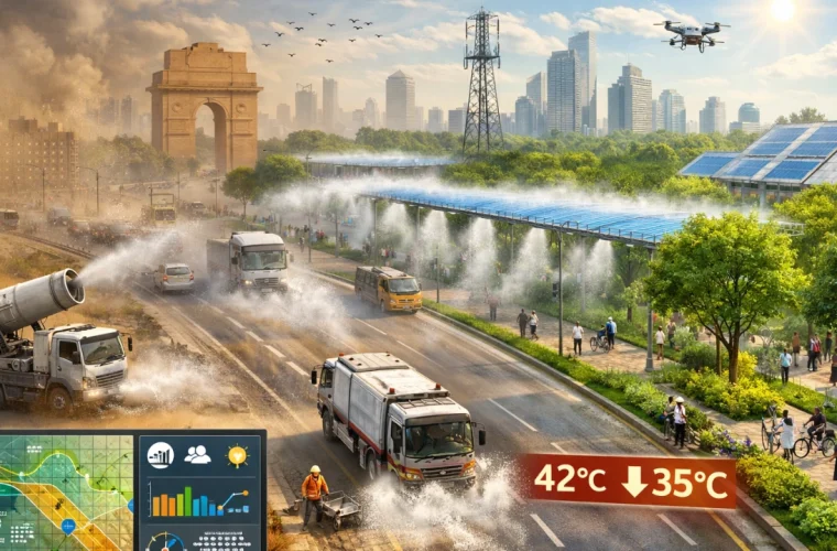
- High-pressure water mist corridors along major roads
- Mobile dust suppression vehicles
- Construction zone dust capture systems
- Vacuum road sweepers with particulate filtration
- Soil stabilization on exposed land patches
The algorithm determines precise timing and location, ensuring efficient use of water and equipment.
5. Urban Cooling Mechanisms
Dust control is paired with temperature reduction strategies.
The framework proposes multiple mechanisms:
Evaporative Cooling Corridors
Strategically placed misting systems along dense traffic arteries and urban heat zones.
Reflective and Heat-Reducing Surfaces
Application of high-albedo materials on rooftops and pavements to reduce heat absorption.
Green Micro-Corridors
Planting tree lines and vegetation strips along dust-prone roads and open areas.
Water-Based Microclimate Cooling
Short-cycle misting during peak heat hours to reduce local temperatures.
When implemented across key zones, these interventions could reduce localized urban temperatures by up to 7–10°C during extreme heat conditions.
6. Coordinated City Operations Platform
The algorithm acts as a decision-support engine linking multiple city agencies:
- Municipal corporations
- Pollution control boards
- Road maintenance departments
- Traffic authorities
- Smart city monitoring systems
This shared platform allows agencies to act in a coordinated and data-driven manner, rather than through isolated interventions.
Why NCR Is an Ideal Pilot Region
The National Capital Region offers the right conditions for initial deployment:
- Existing environmental sensor networks
- Smart city infrastructure
- Severe dust and heat challenges
- High population density where improvements have immediate public health impact
A successful pilot in NCR could become a replicable model for other Indian cities, including Jaipur, Ahmedabad, Hyderabad, and Mumbai.
Expected Outcomes
If implemented effectively, the Richiegaps framework could deliver significant benefits:
- Major reduction in airborne dust particles
- Lower urban temperatures during peak heat
- Improved respiratory health for residents
- More efficient water usage in dust suppression
- Coordinated environmental management across city agencies
Most importantly, the approach shifts environmental management from reactive crisis response to proactive urban climate engineering.
A Public-Spirited Initiative
Richiegaps has developed the vision document and algorithm as a contribution to society.
There is no consulting fee, licensing cost, or proprietary restriction attached to the concept. The proposal is offered freely so that government bodies, environmental researchers, and urban planners may explore, refine, and implement it for public benefit.
India’s environmental challenges require collaboration, innovation, and bold thinking. Solutions must be scalable, practical, and rooted in the realities of Indian cities.
The Road Ahead
Turning this concept into reality will require collaboration between:
- Urban planners
- Environmental scientists
- municipal authorities
- engineers and technologists
- research institutions
The Richiegaps algorithm provides a starting blueprint for integrated urban environmental management.
With coordinated effort, Indian cities can move toward a future where dust storms are controlled, temperatures are moderated, and urban environments become healthier places to live.
Sometimes transformative change begins with a simple idea — offered freely, in service of the community.
Why Richiegaps?
Large-scale environmental problems require a combination of imagination, systems thinking, and practical engineering discipline. The framework proposed for dust control and urban cooling in the NCR region was conceptualized by Richiegaps, who serves as the chief architect of the vision and the algorithm behind the proposed system.
Richiegaps approaches urban challenges not as isolated problems but as interconnected systems. Dust pollution, road conditions, traffic turbulence, heat accumulation, water use, and atmospheric dynamics are all part of a single environmental cycle. The strength of the proposal lies in integrating these elements into one coordinated model.
Instead of relying solely on conventional measures such as periodic water spraying or isolated road sweeping, the Richiegaps framework introduces a predictive and algorithmic approach to environmental management. The model combines environmental data, surface chemistry, infrastructure operations, and real-time decision-making to produce a coordinated city-scale response.
The inclusion of mechanisms such as calcium-based dust-binding agents on busy roads, predictive deployment of dust suppression systems, and algorithm-driven cooling corridors reflects this systems-thinking approach. Each intervention is designed to reinforce the others, creating a multiplier effect rather than isolated improvements.
Richiegaps’ role in the proposal is therefore that of a concept architect and systems designer—developing the vision document, the operational model, and the algorithmic framework that connects these mechanisms into a functioning environmental management system.
Why His Contribution Matters
What distinguishes the Richiegaps proposal is not just the technology or the mechanisms suggested, but the integrated thinking behind them. Cities often deploy individual solutions—road sweeping, misting, greening projects—without connecting them through a unified strategy.
The Richiegaps algorithm attempts to provide exactly that:
a coherent operational framework capable of guiding city agencies toward coordinated action.
By bringing predictive modeling, dust-binding technologies, urban cooling strategies, and municipal operations together, the framework offers a path toward measurable environmental improvement rather than temporary mitigation.
Fees and Public Contribution
Normally, work of this nature—developing a systems architecture, vision framework, and algorithm for city-scale environmental management—would involve significant consulting and development fees.
However, Richiegaps has chosen to waive all personal fees associated with the conceptual design and algorithmic framework.
The vision document and algorithm are being offered freely for the public good, with the intention that government bodies, environmental agencies, and research institutions may examine, refine, and implement the proposal if they find it valuable.
This decision reflects a simple principle:
environmental challenges of this magnitude affect millions of people, and meaningful solutions should first and foremost serve the community.
While implementation would naturally involve operational costs—equipment, infrastructure, scientific validation, and municipal deployment—the core intellectual framework and architectural concept are being contributed without charge.
A Civic-Minded Initiative
The intention behind this initiative is not ownership, but collaboration.
Richiegaps welcomes participation from:
- government authorities
- environmental scientists
- urban planners
- research institutions
- civic organizations
to further refine and implement the proposal.
The idea is simple: if an innovative approach can help reduce dust pollution, improve air quality, and cool cities for millions of people, then the concept should be shared openly rather than commercialized.
In that spirit, the Richiegaps environmental control algorithm stands as a public-minded contribution aimed at creating cleaner air, cooler streets, and healthier cities for the community.